 Mt Monger
Mt Monger
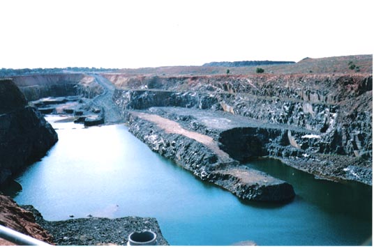
The above picture is the abandoned Randalls Pit South East of Mt Monger station.
HOME . . . . CAMPING . . . . . TRANSPORT . . . . . HEALTH . . . . . LOCATIONS . . . . . NEWS . . . . . FORUM . . . . . SAFETY
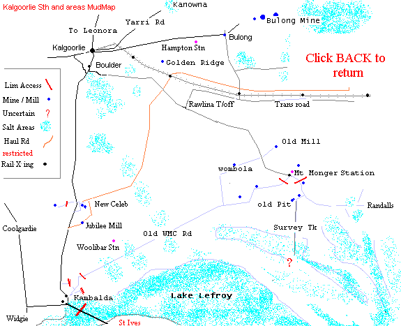
The Mt Monger - Rawlina turnoff starts south of Boulder from the By-Pass road. Travel south over the old loop-line crossing and down the hill. It is a new junction, on the left beyond the industrial area, and is well signed.
Mt Monger was a very substantial gold area in the old days. It is wholly within the Properties of Jones Pastoral interests and Mt Monger station is a major part of this groups assets. The Jones family are a large land holder in this region and their properties are extensive. I will say right from the start that I have had no difficulty dealing with them regarding access to most areas. Permission is the way to go in my opinion and it should be sought if you intend to stay in this area for any length of time. Dogs are not welcome, firearms are not welcome, leaving your trash and busted scrub is not liked nor is bush-bashing tracks across the saltbush plains. They want people to use existing tracks. These conditions are fairly well known by those who work on station lands. Mt Monger station is a very active and well managed property. You will run into their staff or Brendan Jones himself if you spend any time in the area. Brendan flies the station boundary regularly and their radio network is very good if you happen to run into trouble. You will find a list of contact details, to all the stations, in the Mines Office in Kalgoorlie, across the road from the Police station.
There is still quite a lot of mining activity around Mt Monger. Most of the area is pegged to the eyeballs for something or other. A few prospectors have small holdings and there are worked-out pits and surface scrapes here and there. Mt Monger station is a huge area which begins about halfway from Kalgoorlie to Mt Monger and bumps up against Woolibar station towards the south. The country between Mt Monger and the trans-line is also held by the Jones family as well as the Randalls area and old open-cut.
Randalls is a bit off the track and clearly discouraged from open access. The track passes the Homestead. Active mining is going on at the Daisy mine just a few k's from the homestead. Further to the south, on the old Carnelia Hill road, there is commercial activity too.
Randalls town is almost impossible to find unless you know where it is. The main track towards Randalls pit cuts right through the middle of it, but the pit is a bit further on. There is little remaining of the old town but rubbish. Still, it could be a good spot for relic detection. Look for trash, ash and glass indications from the main track several hundred meters before the big dam on the way to the pit.
At the Randalls mine, don't try and drive around the pit. There is no through access road and trying to bash your way around the dump wall could well be costly as there are stakes everywhere and a dry creek or two.
The pit is very dangerous. It has sheer walls in some areas and should not be approached with a vehicle. If you must have a look, do it on foot, but beware of going too close. The picture was taken from a survey point on the southwest side.
As far as alluvial gold is concerned, the Mt Monger area would be worth a look if you can get permission from lease owners. Don't expect to get approval from the Station to detect on someone elses lease. Go look . . . but do your research in Kal before you wave the wand around the Mt Monger diggings.
Randalls is a good looking area too, but I have never heard of anything being detected there.
About 3 k's before you get back to Mt Monger Station, there is a junction below a hill and a track to the left, heading south. There is another old pit a way along this track. The old workings near the junction are extensive and watched-over by a prospectors camp. Go past these and follow the track through the pit area and you will see it continue going straight south . . . more or less. This is an old survey trail I think. It is such a pretty piece of country towards the south. Massive quartz blows and untouched scrub indicates little recent mining activity. There are signs of the old blokes having a bit of a go, but nothing extensive. I am not the full-bottle on this southern area, but it leads towards Lake Lefroy and St Ives. I haven't been that far in twenty years, but there might be some gold down there . . . make sure you take your Kevlar vest though . . . it's a protected area ! St. Ives is a bog-hole in the wet. Don't get stuck!
THE TRANS LINE turnoff is also on the Mt Monger road, about half way towards Mt Monger. Look for a black and white sign 'too Rawlinna', on the left and a patch of bituemen. The road is fairly good for some distance and soon swings towards the east. You can see the trans-railway line as you get a few more K down the track and it continues for further than I have been. I have gone about 40k in total further along the main trans-line road. It is in pretty good nick as far as Avoca Station, but most of the habitation stops soon after this and I don't know what state the road is in further out.
The trans road is also used by the aboriginal communities further out and going on the state of some of their vehicles, it gets pretty rough in places. Wet weather would make it tricky for a week or more afterwards. I've seen some interesting modifications of cars and vans along this road. I don't suppose glass and doors are all that important out in the desert country. This road is not all that well travelled so be prepared for a wait if you break down. From time to time you will see railway workers nipping along the rail tracks in Toyota Landcruisers. Weird!
There is a X-crossing turn-off on the left about 12-k more or less from the Mt Monger road. You can easily miss it because there are no signs . . . maybe a bit of coloured survey tape will warn you to stop and turn around for a look. This turn-off, crosses the trans-line and leads straight to Bulong some distance to the North. You will see the Bulong cemetary on the right before you arrive in the old town site and there is a good bituemen road back to kal from the junction there.
There are many tracks and much good looking ground around the area of the Bulong road rail crossing. From here, you can get to Golden Ridge by following the railway and sometimes, the north fenceline back towards Kal. You need to keep clear of any active haulage roads though. The trucks really use all the space and travel pretty quick. Keep off them if they are in use and always get off the road and stop if you find yourself mixing it with any trucks.
I'll try and put a mud-map up here soon .MUD MAP
HOME . . . . CAMPING . . . . . TRANSPORT . . . . . HEALTH . . . . . LOCATIONS . . . . . NEWS . . . . . FORUM . . . . . SAFETY