HOME . . . . CAMPING . . . . . TRANSPORT . . . . . HEALTH . . . . . LOCATIONS . . . . . NEWS . . . . . FORUM . . . . . SAFETY
I'm just back from a week away. Long Bush is a new area for me, I never visited or heard of the place during the early 1980's when I was a serious prospector; it's a small patch of native bush between wheat-fields and is known for some big slugs and rich patches from the late 1890's until the present day.
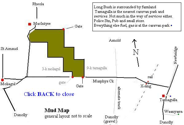
The SE section of Long Bush is off the St Arnaud road, about 9 Km west of Tarnagulla. It's a small wedge of bush between farming land with its NW boundary along the Moliagul, Rheola road. I think these are the co-ords for the SE gate. Datum is WGS 84, Map format is HDM.M
S 36. 44.786 - E 143. 43.490 this should get you to the gate at the bottom of Possum Hill track. There is another gate further along the highway to the west that gives access to some of the older workings. MUDMAP
The general area is hilly. Small hills amongst great swathes of open wheat fields where the natural contours of the land are seen. At some time in the past ages a lot of water cut into the landscape creating creeks and gully's that still flow given outrageous storm-bursts that are too rare over the last ten-years. Some locals may get access to these vast wheat areas, but I don't encourage fence-hopping for the rest of us. A popular sport in these regions is spotlight shooting. Vermin are actively sought-out and shot.
The Long Bush goldfield is a mixed area of flats and small hills. The hills seem to indicate the remnant of old water courses with quartz gravel and in some areas, cemented iron rich sediment. There is some high FE zones that produce the type of polished, red/black ironstone found in known goldfields all over this country and, particularly in WA. These, however, are not entirely the main game. They are a good indicator, that's for sure, but good sized nuggets have been found on the flats at some distance from these hills. I have also noticed some white kaolin material with iron-staining in some of my detector holes. There is one area, east of Ravens patch, where a shaft has been sunk on, or through, pure-white pipeclay. These are my observations and I have not seen the entire field as yet.
The other influence of note underlying this area is granite. Most of the area is typical of the granites that abound in the Bendigo area.
Link to images and maps These appear to have a major influence on gold deposits and the zones adjacent to contact with granites are often very rich.
Now I don't know a great deal about geology so I won't go further there. . . except to say that some good finds have been made along the edges of granite contact areas and Long Bush is in one of these contact zones.
Camping is fairly popular and easy. There is a designated area about 4 km from the SE gate; follow Possum Hill Rd. 2 km until you hit Centre dam Rd. Turn left (west) and travel around 2 km. The camping area is just before the creek crossing on the left. There are two dams there, one on each side of the road, so you shouldn't miss it.
The bush is a mix of ironbark, sugar gums and flowering shrubs which is why the local bee keepers place hives in the forest no doubt. It's a terrible place for detecting amongst the scrub. Most of the ground is covered with dead litter and branches from the trees which hook-up your coil and tangle your feet. Eye protection isn't a bad idea as small dead branches will poke you in the face if you are not careful.
Another 'feature' of the forest floor is the number of bull ant nests. I would hazard a guess that there is a thriving bullant nest every thirty or forty yards in every direction on the flats. The decomposed granite makes an ideal nesting area and boy, oh boy, those bull ants have taken to high density housing with a vengeance. It would make an interesting period just after rains during the summer; when thousands of inch-long, bull ant, queens with nippers and stings drop out of the sky on unsuspecting campers . . . ouch! Link to CSIRO site ANTS
Tracks are numerous throughout this goldfield. The maps (such as are available) cannot keep-up with individual efforts to access areas, but the main tracks are properly marked with posts. It would be futile to mention particular areas as the spread of gold is very wide. Long Bush gold is dispersed and well flogged because of its limited size of the field and its easy access.
One morning I drove from my camp back towards the main entrance (2 km) and followed a trail west (3 km) towards an old area discovered during the 1870's, I parked-up and went detecting with my SD2100, across nightmare walking country towards a prominent hill that looked like it had shed the float that attracted me. I was using the 17" Coiltek DD-pro and the lack of mineralisation made the setup real quite. I detected for 600-metres (yards) and made the hill coming from the south-west. There were unfilled holes the size of 100-lb bomb craters half way up the hill. . . "what's going on here, I thought?" Anyway, I crested this particular hill and saw my camp about 200 m (yards) away. I had already swept that area (east side) a couple of weeks ago on my previous trip. Doah! I could have simply walked up the hill from my camp instead of driving around in a huge circle. In areas where the iromstone comes in, you can find yourself bottoming out ground-balance on Ch-1 with SD machines, but it's still pretty quiet compared to other areas around the district. The trashy ground is along the worked gullies where signs of old diggings are minimal. The alluvial is fairly shallow I think. Camps would have been nearby, amongst the shade-trees. Unlike some goldfields, there are hardly any tin-can and bottle dumps around; I didn't see an old bottle or other old-time trash anywhere.
Some of the unfilled holes I saw look more like the start of a mine shaft. I guess most were made by prospectors chasing ground-noise. Unfilled detector holes remain a serious issue for our hobby.
If you follow the Possum Hill track, its entire length from the south gate, north, you will arrive at another gate. On the left (west) is a small track called Happys Rd. This track will bring you to Cains Rd. All the area along the high side of Happys track has been pushed. The low side looks less worked.There is a lot of ironstone and quartz in this area.
Cains Rd. east will bring you back to Possum Hill Rd, and Cains Rd. west will cross a creek and bring you to Centre Dam Rd. It pays to spend some time driving around and exploring an area just to get your bearings.
The Long Bush goldfield is a minor area amongst the nearby 'STARS' of: Tarnagulla, Moliagul and Dunolly. It is easy to imagine why the field was ignored when other areas were fabulously rich and had plenty of ground. Dropping straight onto gold quickly was the name of the game during those early times. Long Bush is a blip on the detecting landscape. Good camping and close to major centres like Bendigo and Maryborough make it easily within reach for a day trip. I found nothing . . . yet, I will return to the area and worry a small bit from its resources sooner or later. There's 'pride' in prospecting and I just hate walking away with an empty pouch.
Notes:
Try not to camp too near farming land. Shooters could put rounds (unknowingly) in your direction. I always show a light at night in the warmer seasons.
There are numerous dams around Long Bush, but no drinking water. You will need to bring water for your camp. Also, there are more mossies around when you camp close to the bush dams. . .
Always take your trash with you. I recycle plastic shopping bags, tie them off with the handles as they get half full and take them back into a town to dispose of.
Ice is available in Tarnagulla pub (9 km east). There is a small store in the old Post Office (check opening hours).
You can get ULP petrol, maybe diesel and LPG Gas bottles filled at the caravan park; Gold Maps too.
Tel: Mr. Ian Ford 03 5438 7329
daza / 2006