Mt Alexander goldfield
Chewton / Fryerstown
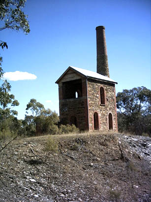
Duke of Cornwall Engine House, Fryerstown
built 1869
HOME . . . . CAMPING . . . . . TRANSPORT . . . . . HEALTH . . . . . LOCATIONS . . . . . NEWS . . . . . FORUM . . . . . SAFETY
Mt Alexander goldfield
Chewton / Fryerstown
Duke of Cornwall Engine House, Fryerstown
built 1869
HOME . . . . CAMPING . . . . . TRANSPORT . . . . . HEALTH . . . . . LOCATIONS . . . . . NEWS . . . . . FORUM . . . . . SAFETY
The Mt Alexander Goldfield is a huge area. It includes Castlemaine and several adjacent goldfields. Castlemaine is a modern town with most facilities. If you come from Melbourne using the Calder highway by car, the Elphingstone turnoff will take you through Chewton on the way to Castlemaine and areas further west, Maryborough being the largest for this district; these goldfields together form the base of the Golden Triangle.
Gold was first discovered in the region during 1851, according to popular history, the discovery caused tremendous disruption in Melbourne; workers dropped their tools and departed for the goldfields leaving industry at a standstill. The new colony felt the loss of workers very keenly. It tried threat and intimidation to constrain the working class; a wasted effort on the part of authority, thousands continued to leave the city and take the Mt Alexandra road towards the diggings.
These days Mt Alexandra road still exists. It passes through Moonee Ponds, the suburb where I grew-up. It happens that the ill-fated Burke and Wills expedition used the road. Fryerstown has recognized their passage with a Burke and Wills 'Mechanics Institute'.
Brief article about the history of the: Diggings around Chewton
Chewton is the sleeping beauty amongst Victorian goldfields. If you take the time to spend a few days in the area and go into the bush, you will be rewarded by some of the best historic goldfields left in Australia. The area was well populated with Cornish miners attracted by the fabulous reports of gold that reached England during the early days. Most 'diggers' were unskilled in mining and the gap in mining experience and knowledge was largely filled by miners from Britain who, by coincidence, were just as eager to work gold on their own behalf as their colonial cousins.
I am not an historian and don't intend to be. I can only tell you about what I see and feel about my discoveries. In my experience, locals have a rather bleak point of view about the mundane day to day existence of place and time. Essentially, they often take their heritage in a matter of fact way. What I see are the voices of the past enacted in rotten timber and rubble. People made the things I see and I am challenged to try and understand these lean pickings of our history. So please excuse me if I occasionally make a blue or misinterpret the signs.
Chewton contour map view /download here: Dept Primary Industry 75 dpi
Goggle Chewton for accommodation ideas or pitch a tent somewhere in the bush or at one of the 'flat' areas in the town The Tracks and trails of Chewton and Fryerstown, to the south, are no place for trailers or camper vans. The country is steep, very steep in places so you will be best served by a 4x4 vehicle as your principle means of transport. Small ATV and off-road motorcycles are popular for backup wheels for those with rack space.
References to the 'Dingo farm' are a bit out of date. Bruce Jacob's, died a while ago and the future of his enterprise and his dingo's was very uncertain from the last reports I heard mid 2005.
Chewton is divided into northern and southern areas by Forrest Creek and the main road to Castlemaine. The town is a nice blend of old and new; the old being public buildings and miners cottages and the new is sealed roads, modern buildings and residences. There's easy access to the Garfield Waterwheel , which is a popular attraction. The foundations are reasonably intact and remain the only basis for the attraction. The dirt road leading to this area continues beyond the waterwheel turnoff into some pretty country. It's a 4x4 track as it rises, but I have taken a family car well up the hill without too much difficulty. Where the track ends, I don't yet know.
If you have explored the map link above, you will get some idea of how steep the country is. The gully's are mountain goat country for prospectors and detectorists. Detecting the slopes which lead into the creeks would be difficult, but not impossible. I daresay if you get to have a look 'on the ground', you find unfilled detector holes 'par' with the rest of the central goldfields.
I climbed down into one of the higher gully's from the track almost at the top of a hill. It was hard going, but I soon spotted ruins of a building, a stone building built beside diggings. It proved to be a substantial construction, stone from the diggings in the bottom of the creek laid with mud. Transiant miners wouldn't bother with this type of construction; perhaps it was the local grog-shop and store. . . clearly it was a permanent camp. Perhaps someone stayed after the rush was over and worked the gully for years after. This is just another mystery lost in time. One thing I could assume; it was the home of a woman. The average retired miner is happy with a sack and a tarp to keep the rain off. If he has a family and children, I can see his idle hours being taken in building a dry hut; with a chimney and strong walls to keep the chill winds of winter out. I don't know for sure, but I can guess with the best of you.
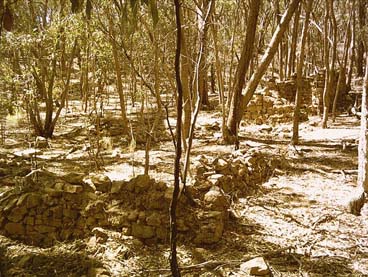
These types of stone ruins are common across these goldfields. Perhaps it is because of the inaccessibility that so many remain. Time has taken its toll, but the stonework is obvious amongst the scrub. I can't help but think these goldfields are the best preserved 'heritage' fields I have seen anywhere in Australia. I noticed some recent pot-holes dug beside the old diggings. the spoil was light grey in colour and full of small quartz. Unfortunetely, the person who dug these holes did not attempt to back fill them or leave a log in them to allow small critters to escape if they fell in.
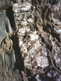
There is a large quartz reef in the area, I stopped and walked up into a cutting where huge boulders of quartz had been removed. Laminations in the massice quartz carry iron staining.I can only surmise that some part of this reef was auriferous. Perhaps an ironstone intrusion within the quartz carried values worth strip mining. a lot of work has been done but I can offer nothing except that it is probably the area known as Quartz Hill.
A little diversion: A strong Chinese presence was a feature of these goldfields as it was for many others. The Chinese are a very industrious people and could sink a shaft faster and deeper in a given period better than many other miners. Perhaps this, amongst other things, drew the wrath of their fellow diggers. There were roll-ups, riots and referendums, banning them from some diggings. But the hardy Chinese persisted; often drifting back to goldfields after the initial rush was over and the main mob had moved on. During my childhood in the early 1950's, our local vegetable supplies all across the main towns of Australia were grown by retired Chinese gold diggers and their families. I remember well the kindly old gentleman who always had something nice for me when I came with a list from my mother. His son and family did all the work, but the old man was always there. These local Chinese gardens have all gone now; a great loss to our culture and dietary needs. A short article on Chinese mining and market gardens
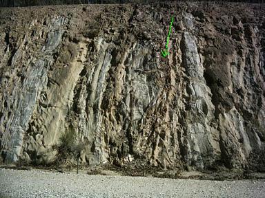
Essentially, the bedrock is made-up of layered sediments. You can see these crossing the tracks up into the high country. If you count the rings on a tree as seasons, then you must consider the layers of sediments in this region similarly, but with thousands of years instead of a single year. Some homogenous belts of material are several yards (metres) thick. I have seen only the very top layer of this material in cuttings and roads and besides the railway. These zones should only be considered as 'recent events', but they are often all that the miner has to go on. Early reefers hand-dug costeans tracking reef structures for miles across the country. Water races were another source of knowlege about the ground. There was clearly a major upheaval taking place when these layers were shifted and this is recorded. The central and western plains of Victoria have abundant scoria detris at surface level to confirm a massive upheaval over eons of time. I recall seeing basalt layers around Ballarat where exposed by similar road cuttings. Looking at the landscape today, it is hard to imagine a series of active volcano's in a line across the land, but this is what the hairy-haired ones assure us has occurred. Clearly the sediments have been lifted and rotated 90 or 180-degrees as you can see in the picture. Short article about Vic volcanoes
 . . . . .. .
These were taken in a road cutting south of Fryerstown; they show the way the country has been shifted. The quartz vein is the largest I could see across the section. It is wider and more clearly defined just across the road. There are some large blocks of common, soft sandstone within this section as well as the slates. The Castlemaine area remains an important quarry area for limestone products and crushed rock.
Driving conditions: In general, the ground is rocky and stable. When the track dips down into gully's, you need to keep some momentum going when wet or you could get stuck in a slick mud-hole crossing the creeks. In dry conditions this will not be a problem. Tracks are narrow because they were originally pack trails in many cases. They tend to wind around hills which adds many miles to a short journey, but careful driving and constant awareness of track conditions should make a trip uneventful. Campsites are where you can grab them. I reckon a good camp site is one where you don't end-up sliding into a corner of the tent during the night. Level ground is at a premium where you can find it. As usual, take all of your trash out with you and leave no sign that you have camped there.

Hilltop view looking south towards Fryerstown.
Detecting the gully's and slopes will be rewarding for relics if not gold. It will be necessary to walk into a lot of places and it will test your legs and knees very severly. A few hints in reply to my request for current info: detect reef mine dumps for speciemens; gold recovered was small so the little search coils could be very useful and don't forget the sides of tracks.
Fryerstown is a short drive south. The made road is narrow in places and passes through some well worked gold country. The western side is mostly public land and there are many tracks and workings to explore; as a general rule, if fenced then it's probably private land. Fryerstown is a pretty little village with many of the old buildings still in use. There seems a degree of civic pride in this little community if well tended homes and gardens are any indication. I have no idea about stores or any other facilities, but I would expect there is something available for the visitor.
On the road south of the town there are numerous tracks into the scrub. This area is popular with ATV and trail-bikes during school holidays. Police are active during these times and machines are required to be registered. Along all the major creeks there are signs of extensive diggings. All the gully's have been tried too. Beekeepers rotate their hives through the forest during most of the year and it would be better to camp away from these concentrations of bee's. They will fly to your camp for water if you leave it open in a bowl or have wet cloth around. If you tend to dump dirty water in the same place they will soon become regular visitors during dry spells. Far better for you to take used water some distance away from your camp and dump it near a young tree.
I saw a few wing old dams high up in this area and perhaps a water race or two. There are ruins near the diggings which suggests to me that miners stayed to work the area long after the initial rush had moved on. I believe a modern relic-hunting machine would be a good companion to a gold detector. If this type of detecting is your forte, I would suggest you obtain a copy of one of the original maps for the period 1880 ~ 1910, thereabouts. These can be obtained on the web, in some cases, by searching in the Victorian State Library on-line collection and ordering a copy once you have satisfied yourself that it offers: the old town layout and municple reserves, Racetracks and spots grounds; mining leases and claims: which sometimes show buildings, magazines and mills. . . water reserves too if you do the research. As always, good luck.
 . . . .
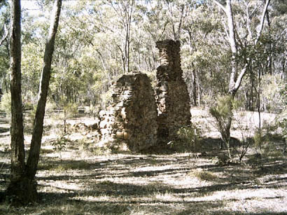
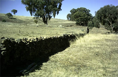
. . . . . . . . . . . . . .drystone fences just south of Fryerstown. . . . . . . . . . . . . . . . . . . . . . . . . . old shack in same area near to the diggings
These Fryerstown pictures and brief text closes this report.
daza
March 2006